![[SAR Sunburst]](http://www.sar.org/gifs/sarsun.gif)
![]()
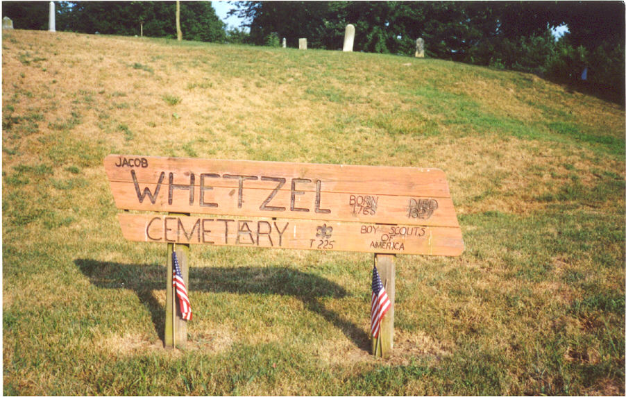
JACOB WHETZEL
![]()
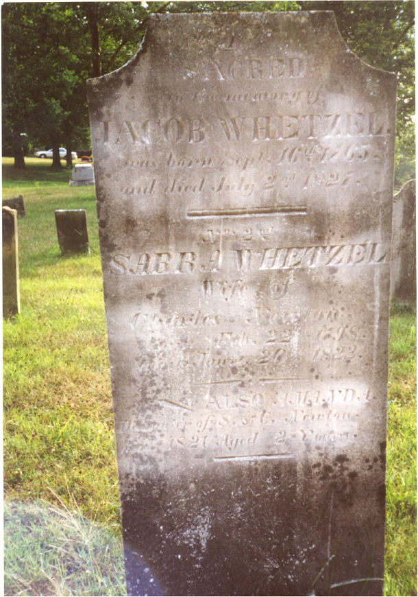
Born: Sept 11, 1765 Rockingham County, Virginia
Died: July 2, 1821
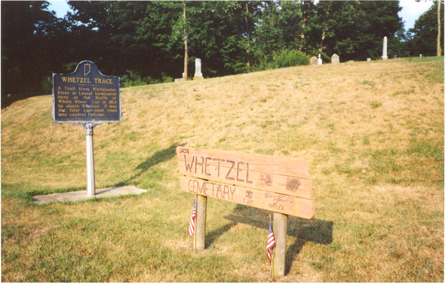
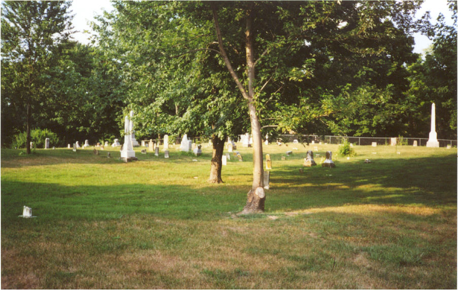
Burial: Whetzel / McKenzie Cemetery, about 1/2 mile from center of Waverly,Morgan County,Indiana
Service:REVOLUTIONARY WAR INFO
4TH CAVLRY (77TH) REGIMENT.
John G. Moore, Commissary.
Company L.
Josiah Hartly, Captain.
Thos. C. Cunningham, 1st Lieut.
John E. Hendricks, 1st Lieut.
John J. Phillips, 2nd Lieut.
George E. Grace, 2nd Lieut.
Jeremiah Antle, Daniel Berney, George Blackmore, John N. Butler, John H. Clever, Simon Clever, Geo. B. Covell, Wm. H. Cox, Joshua Cox, Edward Cox, Wm. Currie, Geo. H. Curry, James Curry, Samuel Day, Wm. Deitz, Wm. Dinwodie, John Duke, Robert Dunlap, Wm. H. Dunn, Wm. F. Falconer, Wm. T. Fenton, Benton Folkner, Frances Furgason, Oliver Gonter, Solomon E. Hampton, James A. Hanna, Thos. J. Hanna, James H. Harris, Daniel T. Jones, Joseph King, Benjamin King, Wm. H. Lick, David Lippert, Dailey Loyd, Ezekiel Loyd, Squire Mather, Alexander P. McCan, Wm. A. McBride, Nick McCubbin, Jas. D. McIntire, Jas. McNeil, Jr., John Merriman, Granville Merriman, Ferdinand Miller, Chas. S. Mullen, John Mullen, Joseph Park, Hugh H. Parkhell, Isac D. Perkins, Wm. Ramsey, John J. Rutherford, Wm. Schaab, Johnathon Schooley, John Stofer, Casper Snyder, Benjamin Sullender, Addison Sullivan, Henry Talbott, Jesse Temple, Jas. N. Temple, George Thompson, Jessie W. Tilford, Isaac Tyron, Valentine Wetzel, Jacob Wetzel, Wm. A. White, Michael Wood.
(*note Spelling variations has always been a issue in any of the geneaology researching)
Proof:
Married:
Children:
 |
 |
 |
|
 |
 |
 |
|


ANYONE WITH INFORMATION ON THIS PATRIOT
I'D APPRECIATE HEARING FROM YOU.Stephen D Franklin
From there at County Road 144, the Dairy Queen, heading West cross over State Road 37... About mile-ish on Left is BLUFF CREEK CHURCH... There is Cemetery there... And Salem Cemetery is just one West from Bluff Creek the first Left off of 144 go down just a piece and there will be a VERY SHARP RIGHT bend in road ... You will see it on left .... The Gate Irons still has SALEM over archway . I can't remember new name of chruch there now. Both are very old cemeteries also. The church at Bluff Creek was re-built and doesn't look as old as the cemetery...
Our Soldiers and Sailors
Who Fought For Freedom.
,br> From Our City and Our Heroes, by A. S. Chapman, 1908.
Original booklet held at the Jefferson County Historical Society
G.A.R. Collection MC-26.
From this site: http://www.indyofficespace.com/market_history.html
History of Indianapolis
"The Crossroads of America"
It is a typically American city in a typically American state…the physical, political, economic, and cultural capital of a great commonwealth…a city proud and grateful for its heritage, industrious, ambitious, and confident of a glowing destiny.
About Indianapolis there is no element of circumstance either in the selection of its site or the design for the original town. And today, as from the beginning, it is a city planned in its development.
The first settlers came here in the spring of 1820. They located at or near the confluence of Fall Creek and White River. A few years earlier trader William Conner had established a thriving trading post (now restored) a few miles northeast, but it was to the south of Fall Creek that pioneers, pressing into the new state, directed their course from Connersville, Andersontown, and other older towns. Andersontown was a village of the Delaware Indians.
Jacob Whetzel and his son came from Andersontown after gaining permission from ruling Chief Anderson to blaze a trail to the mouth of Fall Creek. The white man's treaty with Chief Anderson had given the venerable Delaware control over the entire area for one full year, and Whetzel was meticulous in his determination to observe the treaty...
The information & Directions to cemtery were gathered on this site from Paula The patriots name came up reviewing Morgan County Indiana Cemetery records.
Anyone having information on this Soldier whether it be the Revolutionary War or maybe the War of 1812, please contact Stephen D. Franklin
The Indiana State Society SAR Homepage